
Buloyer topographic map
Interactive map
Click on the map to display elevation.
About this map
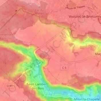
Name: Buloyer topographic map, elevation, terrain.
Average elevation: 154 m
Minimum elevation: 87 m
Maximum elevation: 175 m
Other topographic maps
Click on a map to view its topography, its elevation and its terrain.
Magny-Village
France > Île-de-France > Yvelines > Magny-les-Hameaux
Magny-Village, Magny-les-Hameaux, Rambouillet, Yvelines, Île-de-France, France métropolitaine, 78114, France
Average elevation: 153 m
Villeneuve
France > Île-de-France > Yvelines > Magny-les-Hameaux > Magny-Village
Villeneuve, Magny-Village, Magny-les-Hameaux, Rambouillet, Yvelines, Île-de-France, France métropolitaine, 78114, France
Average elevation: 149 m