
Special capital Region of Jakarta topographic map
Interactive map
Click on the map to display elevation.
Special capital Region of Jakarta
Jakarta lies in a low and flat alluvial plain, ranging from −2 to 91 m (−7 to 299 ft) with an average elevation of 8 m (26 ft) above sea level with historically extensive swampy areas. Some parts of the city have been constructed on reclaimed tidal flats that occur around the area. Thirteen rivers flow through Jakarta. They are Ciliwung River, Kalibaru, Pesanggrahan, Cipinang, Angke, Maja, Mookervart, Krukut, Buaran, West Tarum, Cakung, Petukangan, Sunter River and Grogol River. They flow from the Puncak highlands to the south of the city, then across the city northwards towards the Java Sea. The Ciliwung River divides the city into the western and eastern districts. These rivers, combined with the wet season rains and insufficient drainage due to clogging, make Jakarta prone to flooding.
About this map
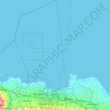
Name: Special capital Region of Jakarta topographic map, elevation, terrain.
Location: Special capital Region of Jakarta, Java, Indonesia (-6.37446 106.31467 -4.99936 106.97398)
Average elevation: 5 m
Minimum elevation: -3 m
Maximum elevation: 198 m
Other topographic maps
Click on a map to view its topography, its elevation and its terrain.