
La Saigne topographic map
Interactive map
Click on the map to display elevation.
About this map
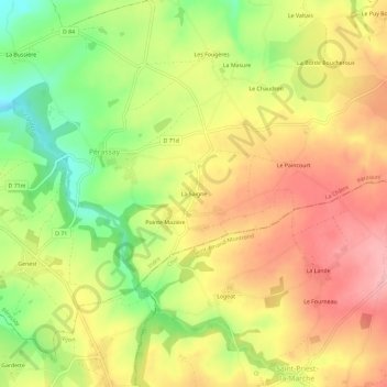
Name: La Saigne topographic map, elevation, terrain.
Average elevation: 377 m
Minimum elevation: 303 m
Maximum elevation: 437 m
Other topographic maps
Click on a map to view its topography, its elevation and its terrain.
Genest
France > Centre-Val de Loire > Indre > Pérassay
Genest, Pérassay, La Châtre, Indre, Centre-Val de Loire, France métropolitaine, 36160, France
Average elevation: 360 m
Les Fossés
France > Centre-Val de Loire > Indre > Pérassay
Les Fossés, Pérassay, La Châtre, Indre, Centre-Val de Loire, France métropolitaine, 36160, France
Average elevation: 331 m