
Lewis Pass topographic map
Interactive map
Click on the map to display elevation.
About this map
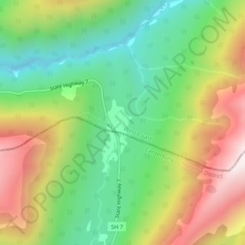
Name: Lewis Pass topographic map, elevation, terrain.
Location: Lewis Pass, Buller District, West Coast, New Zealand (-42.37855 172.40098 -42.37845 172.40108)
Average elevation: 1,039 m
Minimum elevation: 680 m
Maximum elevation: 1,547 m
Other topographic maps
Click on a map to view its topography, its elevation and its terrain.
Mokihinui
New Zealand > West Coast > Buller District
Mokihinui, Buller District, West Coast, New Zealand
Average elevation: 55 m
Charleston
New Zealand > West Coast > Buller District
Charleston, Buller District, West Coast, New Zealand
Average elevation: 24 m
Granity
New Zealand > West Coast > Buller District
Granity, Buller District, West Coast, New Zealand
Average elevation: 150 m
Cape Foulwind
New Zealand > West Coast > Buller District > Cape Foulwind
Cape Foulwind, Buller District, West Coast, New Zealand
Average elevation: 14 m
Hukarere
New Zealand > West Coast > Buller District
Hukarere, Buller District, West Coast, New Zealand
Average elevation: 131 m
Ikamatua
New Zealand > West Coast > Buller District
Ikamatua, Buller District, West Coast, New Zealand
Average elevation: 122 m
Westport
New Zealand > West Coast > Buller District
Westport, Buller District, West Coast, 7825, New Zealand
Average elevation: 13 m
Reefton
New Zealand > West Coast > Buller District
Reefton, Buller District, West Coast, 7830, New Zealand
Average elevation: 310 m