
Pend Oreille Mine Tailings Pond Dam topographic map
Interactive map
Click on the map to display elevation.
About this map
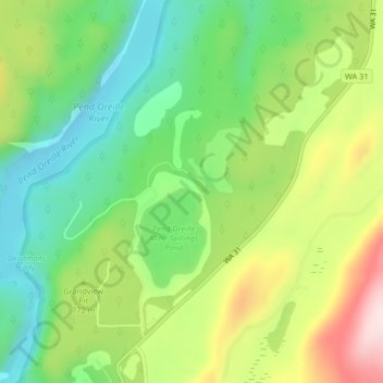
Name: Pend Oreille Mine Tailings Pond Dam topographic map, elevation, terrain.
Average elevation: 741 m
Minimum elevation: 597 m
Maximum elevation: 968 m
Other topographic maps
Click on a map to view its topography, its elevation and its terrain.
Ione
United States > Washington > Pend Oreille County
Ione, Pend Oreille County, Washington, 99139, United States
Average elevation: 670 m
Pend Orielle River
United States > Washington > Pend Oreille County
Pend Orielle River, Pend Oreille County, Washington, 83822, United States
Average elevation: 1,060 m
Metaline
United States > Washington > Pend Oreille County
Metaline, Pend Oreille County, Washington, 99152, United States
Average elevation: 713 m
Deer Valley
United States > Washington > Pend Oreille County
Deer Valley, Pend Oreille County, Washington, United States
Average elevation: 724 m
Kalispel Reservation
United States > Washington > Pend Oreille County > Airway Heights
Kalispel Reservation, Airway Heights, Pend Oreille County, Washington, United States
Average elevation: 801 m
Metaline Falls
United States > Washington > Pend Oreille County
Metaline Falls, Pend Oreille County, Washington, 99153, United States
Average elevation: 720 m
Mill Creek Point
United States > Washington > Pend Oreille County
Mill Creek Point, Pend Oreille County, Washington, United States
Average elevation: 1,275 m