
Serra topographic map
Interactive map
Click on the map to display elevation.
About this map
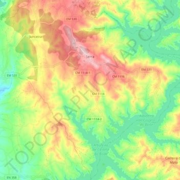
Name: Serra topographic map, elevation, terrain.
Average elevation: 181 m
Minimum elevation: 65 m
Maximum elevation: 329 m
Other topographic maps
Click on a map to view its topography, its elevation and its terrain.
Outeiro do Forno
Portugal > Centro > Tomar > Serra > Outeiro do Forno
Outeiro do Forno, Serra, Serra e Junceira, Tomar, Santarém, Médio Tejo, Centro, 2300-236, Portugal
Average elevation: 167 m