
Buntzen Lake topographic map
Interactive map
Click on the map to display elevation.
About this map
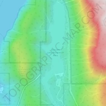
Name: Buntzen Lake topographic map, elevation, terrain.
Average elevation: 348 m
Minimum elevation: 0 m
Maximum elevation: 1,158 m
Hiking time: 6–8 hours return. Distance: 15 km (9 mi). Elevation gain: 1,020 m (3,350 ft). This is the most popular of the three Halvor Lunden trails. It passes thought ancient mountain forests and has a number of viewpoints from which overlook Vancouver. The trailhead is on Powerhouse Road, near the southeast corner of the South Beach parking area, and takes you up a steep climb of over 700m, passing the Polytrichum Lookout before reaching the "Lake district" which includes several small lakes and the larger Lindsay Lake.
Other topographic maps
Click on a map to view its topography, its elevation and its terrain.
Buntzen Bay
Canada > British Columbia > Metro Vancouver Regional District > Anmore
Buntzen Bay, Anmore, Metro Vancouver Regional District, British Columbia, Canada
Average elevation: 214 m
Burrard Inlet
Canada > British Columbia > Metro Vancouver Regional District > Anmore
Burrard Inlet, Anmore, District of North Vancouver, Metro Vancouver Regional District, British Columbia, Canada
Average elevation: 478 m