
Tamworth topographic map
Interactive map
Click on the map to display elevation.
About this map
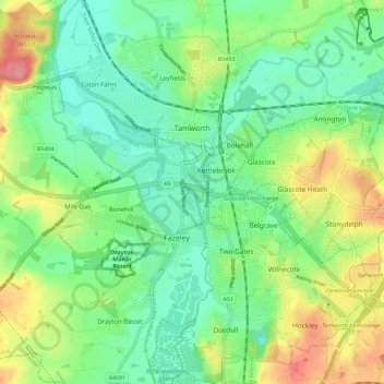
Name: Tamworth topographic map, elevation, terrain.
Location: Tamworth, Staffordshire, England, United Kingdom (52.58867 -1.73582 52.65750 -1.63293)
Average elevation: 76 m
Minimum elevation: 47 m
Maximum elevation: 130 m
Other topographic maps
Click on a map to view its topography, its elevation and its terrain.
Upper Tean
United Kingdom > England > Staffordshire > Staffordshire Moorlands
Upper Tean, Staffordshire Moorlands, Staffordshire, England, ST10 4EH, United Kingdom
Average elevation: 175 m
Woodlands Road
United Kingdom > England > Staffordshire > Stafford
Woodlands Road, Stafford, Staffordshire, England, United Kingdom
Average elevation: 85 m
Kidsgrove
United Kingdom > England > Staffordshire > Newcastle-under-Lyme
Kidsgrove, Newcastle-under-Lyme, Staffordshire, England, United Kingdom
Average elevation: 161 m
Biddulph
United Kingdom > England > Staffordshire > Staffordshire Moorlands
Biddulph, Staffordshire Moorlands, Staffordshire, England, United Kingdom
Average elevation: 210 m
Rugeley
United Kingdom > England > Staffordshire > Cannock Chase
Rugeley, Cannock Chase, Staffordshire, England, United Kingdom
Average elevation: 90 m
Prospect Village
United Kingdom > England > Staffordshire > Cannock Chase
Cannock Wood, Prospect Village, Cannock Chase, Staffordshire, England, United Kingdom
Average elevation: 192 m
Swan Bank
United Kingdom > England > Staffordshire > Newcastle-under-Lyme > Madeley Heath
Swan Bank, Madeley, Madeley Heath, Newcastle-under-Lyme, Staffordshire, England, CW3 9JY, United Kingdom
Average elevation: 135 m
Keele
United Kingdom > England > Staffordshire > Newcastle-under-Lyme
Keele, Newcastle-under-Lyme, Staffordshire, England, United Kingdom
Average elevation: 166 m
Cannock Chase
United Kingdom > England > Staffordshire
Cannock Chase, Staffordshire, England, United Kingdom
Average elevation: 142 m
Cannock
United Kingdom > England > Staffordshire > Cannock Chase
Hednesford, Cannock, Cannock Chase, Staffordshire, England, United Kingdom
Average elevation: 185 m
Burntwood
United Kingdom > England > Staffordshire > Lichfield > Chasetown
Burntwood, Chasetown, Lichfield, Staffordshire, England, United Kingdom
Average elevation: 147 m
Tamworth
United Kingdom > England > Staffordshire > Tamworth > Tamworth
Tamworth, Staffordshire, West Midlands, England, B79 7DA, United Kingdom
Average elevation: 76 m
The Moss
United Kingdom > England > Staffordshire > Newcastle-under-Lyme > Madeley > The Moss
The Moss, Madeley, Newcastle-under-Lyme, Staffordshire, West Midlands, England, CW3 9NN, United Kingdom
Average elevation: 122 m
Perton
United Kingdom > England > Staffordshire > South Staffordshire
Perton, South Staffordshire, Staffordshire, England, United Kingdom
Average elevation: 123 m