
Rio Grande County topographic map
Interactive map
Click on the map to display elevation.
About this map
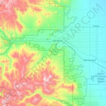
Name: Rio Grande County topographic map, elevation, terrain.
Location: Rio Grande County, Colorado, Estados Unidos (37.39830 -106.71276 37.83525 -106.03832)
Average elevation: 2,771 m
Minimum elevation: 2,310 m
Maximum elevation: 4,031 m
Other topographic maps
Click on a map to view its topography, its elevation and its terrain.
San Miguel County
San Miguel County, Colorado, Estados Unidos
Average elevation: 2,390 m