
Toronto topographic map
Interactive map
Click on the map to display elevation.
About this map
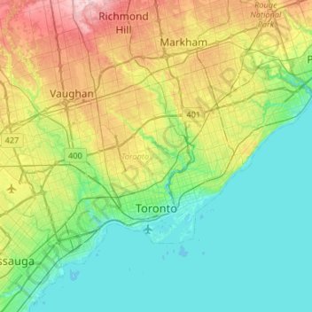
Name: Toronto topographic map, elevation, terrain.
Location: Toronto, Golden Horseshoe, Ontario, Canada (43.58025 -79.63927 43.85544 -79.11322)
Average elevation: 140 m
Minimum elevation: 69 m
Maximum elevation: 332 m
Malgré la présence de nombreux ravins, Toronto n'est pas une ville spécialement vallonnée. Son altitude est comprise entre 75 mètres au-dessus du niveau de la mer au niveau du lac Ontario et 209 mètres près de l'Université York au nord de la ville, à l'intersection entre la rue Keele et l'avenue Steeles.
Other topographic maps
Click on a map to view its topography, its elevation and its terrain.