
Thank you for supporting this site ❤️
Make a donation
Make a donation
Juneau County topographic map
Click on the map to display elevation.
Thank you for supporting this site ❤️
Make a donation
Make a donation
About this map
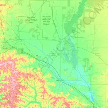
Name: Juneau County topographic map, elevation, terrain.
Location: Juneau County, Wisconsin, United States (43.64070 -90.31282 44.24971 -89.78543)
Average elevation: 302 m
Minimum elevation: 253 m
Maximum elevation: 441 m
Thank you for supporting this site ❤️
Make a donation
Make a donation
Other topographic maps
Click on a map to view its topography, its elevation and its terrain.
Two Creeks Buried Forest State Natural Area
United States > Wisconsin > Kewaunee County
Average elevation: 187 m