
Antoine topographic map
Interactive map
Click on the map to display elevation.
About this map
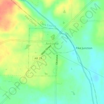
Name: Antoine topographic map, elevation, terrain.
Location: Antoine, Pike County, Arkansas, United States (34.02780 -93.42827 34.04023 -93.41353)
Average elevation: 90 m
Minimum elevation: 70 m
Maximum elevation: 118 m
Elevation is 300 feet (91 m) above sea level.
Other topographic maps
Click on a map to view its topography, its elevation and its terrain.
Crater of Diamonds State Park
United States > Arkansas > Pike County > Murfreesboro > Kimberley
Crater of Diamonds State Park, Kimberley, Murfreesboro, Pike County, Arkansas, 71958, United States
Average elevation: 106 m
Little Missouri River
United States > Arkansas > Pike County
Little Missouri River, Pike County, Arkansas, 71958, United States
Average elevation: 159 m
Glenwood
United States > Arkansas > Pike County
Glenwood, Pike County, Arkansas, 71943, United States
Average elevation: 193 m
Delight
United States > Arkansas > Pike County > Delight
Delight, Pike County, Arkansas, 71940, United States
Average elevation: 119 m
Lake Greeson
United States > Arkansas > Pike County
Lake Greeson, Pike County, Arkansas, 71950, United States
Average elevation: 195 m
Murfreesboro
United States > Arkansas > Pike County
Murfreesboro, Pike County, Arkansas, 71958, United States
Average elevation: 114 m