
Derbyshire topographic map
Interactive map
Click on the map to display elevation.
About this map
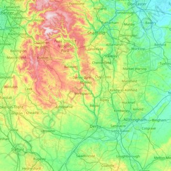
Name: Derbyshire topographic map, elevation, terrain.
Location: Derbyshire, England, United Kingdom (52.69652 -2.03410 53.54045 -1.16649)
Average elevation: 144 m
Minimum elevation: 0 m
Maximum elevation: 637 m
Due to its central location in England and altitude range from 27 metres in the south to 636 metres in the north, Derbyshire contains many species at the edge of their UK distribution ranges. Some species with a predominantly northern British distribution are at the southern limit of their range, whilst others with a more southern distribution are at their northern limit in Derbyshire. As climate change progresses, a number of sensitive species are now being seen to be either expanding or contracting their range as a result. For the purposes of protecting and recording the county's most important habitats, Derbyshire has been split into two regions, each with its own Biodiversity Action Plan (BAP), based around National Character Areas. The Peak District BAP includes all of Derbyshire's uplands of the Dark Peak, South-West Peak and White Peak, including an area of limestone beyond the national park boundary. The remaining areas are monitored and recorded in the Lowland Derbyshire Biodiversity Action Plan, which subdivides the landscape into eight smaller Action Areas.
Other topographic maps
Click on a map to view its topography, its elevation and its terrain.
London
United Kingdom > England > London
London, Greater London, England, SW1A 2DX, United Kingdom
Average elevation: 42 m
Greater Manchester
Greater Manchester, England, United Kingdom
Average elevation: 141 m
Bristol
United Kingdom > England > City of Bristol
Bristol, City of Bristol, West of England, England, United Kingdom
Average elevation: 55 m
Plymouth
United Kingdom > England > Devon > Plymouth
Plymouth, Devon, South West England, England, PL1 1HH, United Kingdom
Average elevation: 81 m
Somerset
Somerset, South West England, England, United Kingdom
Average elevation: 87 m
Sheffield
Sheffield, South Yorkshire, England, United Kingdom
Average elevation: 168 m
Nottingham
United Kingdom > England > Nottinghamshire
Nottingham, England, United Kingdom
Average elevation: 56 m
Leeds
United Kingdom > England > Leeds
Leeds, Yorkshire and the Humber, England, LS1 6AL, United Kingdom
Average elevation: 94 m
Oxford
United Kingdom > England > Oxfordshire
Oxford, Oxfordshire, England, United Kingdom
Average elevation: 81 m
Cambridge
United Kingdom > England > Cambridge
Cambridge, Cambridgeshire, East of England, England, United Kingdom
Average elevation: 18 m
Newcastle upon Tyne
Newcastle upon Tyne, North of Tyne, England, United Kingdom
Average elevation: 57 m
London
London, Greater London, England, United Kingdom
Average elevation: 66 m
Portsmouth
United Kingdom > England > Hampshire > Portsmouth
Portsmouth, Hampshire, South East England, England, PO1 5QH, United Kingdom
Average elevation: 28 m
Colchester
United Kingdom > England > Essex
Colchester, Essex, England, United Kingdom
Average elevation: 28 m
Birmingham
Birmingham, West Midlands Combined Authority, England, United Kingdom
Average elevation: 138 m
Milton Keynes
United Kingdom > England > Milton Keynes > Milton Keynes
Milton Keynes, South East England, England, MK9 3AF, United Kingdom
Average elevation: 81 m
Leicester
United Kingdom > England > Leicestershire
Leicester, Leicestershire, England, LE1 5YA, United Kingdom
Average elevation: 109 m
Brighton
United Kingdom > England > Brighton and Hove
Brighton, Brighton and Hove, England, United Kingdom
Average elevation: 64 m
South East England
South East England, England, United Kingdom
Average elevation: 69 m
Northamptonshire
Northamptonshire, England, United Kingdom
Average elevation: 97 m
Dartmoor National Park
United Kingdom > England > Devon
Dartmoor National Park, Devon, England, United Kingdom
Average elevation: 239 m
City of London
United Kingdom > England > City of London > City of London
City of London, England, EC2V 5AE, United Kingdom
Average elevation: 42 m
North Yorkshire
North Yorkshire, Yorkshire and the Humber, England, United Kingdom
Average elevation: 153 m
Redditch
United Kingdom > England > Worcestershire
Redditch, Worcestershire, England, United Kingdom
Average elevation: 99 m
Corby
United Kingdom > England > North Northamptonshire > Corby
Corby, North Northamptonshire, East Midlands, England, United Kingdom
Average elevation: 98 m
Chelmsford
United Kingdom > England > Essex
Chelmsford, Essex, England, United Kingdom
Average elevation: 54 m
Derby
United Kingdom > England > Derbyshire
Derby, Derbyshire, England, DE1 2AA, United Kingdom
Average elevation: 96 m
Durham
United Kingdom > England > County Durham
Durham, County Durham, North East, England, DH1 3NG, United Kingdom
Average elevation: 119 m
Lincolnshire
Lincolnshire, East Midlands, England, United Kingdom
Average elevation: 28 m
Dorset
United Kingdom > England > Talbot Village
Dorset, Alder Road, Branksome, Talbot Village, Bournemouth, Christchurch and Poole, South West England, England, BH12 5BJ, United Kingdom
Average elevation: 57 m
Cambridgeshire
Cambridgeshire, Cambridgeshire and Peterborough, England, United Kingdom
Average elevation: 32 m
Northumberland
Northumberland, North of Tyne, England, United Kingdom
Average elevation: 141 m
Hampshire
Hampshire, South East, England, United Kingdom
Average elevation: 73 m
Hemel Hempstead
United Kingdom > England > Hertfordshire > Dacorum
Hemel Hempstead, Dacorum, Hertfordshire, England, HP1 1EW, United Kingdom
Average elevation: 130 m
Tonbridge
United Kingdom > England > Kent > Tonbridge and Malling
Tonbridge, Tonbridge and Malling, Kent, England, TN9 2AN, United Kingdom
Average elevation: 55 m
Bath
United Kingdom > England > Bath and North East Somerset
Bath, Bath and North East Somerset, West of England, England, United Kingdom
Average elevation: 100 m
Crawley
United Kingdom > England > West Sussex
Crawley, West Sussex, England, United Kingdom
Average elevation: 80 m