
Make a donation
Long Reef topographic map
Click on the map to display elevation.
Make a donation
About this map
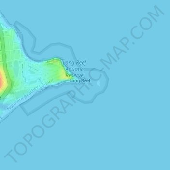
Name: Long Reef topographic map, elevation, terrain.
Average elevation: 1 m
Minimum elevation: -1 m
Maximum elevation: 42 m
Make a donation
Other topographic maps
Click on a map to view its topography, its elevation and its terrain.
Make a donation
Woronora
Australia > New South Wales > Sydney
Woronora Plateau, is a geographical region adjacent to the Sydney Plain. Slightly higher in altitude, it is capped with Hawkesbury Sandstone. The Woronora River flows through the deeply dissected plateau to the Georges River from near the sources of the Port Hacking, within the Sutherland Shire.
Average elevation: 65 m
Make a donation
Make a donation
Make a donation
Wentworth Falls
Australia > New South Wales > Sydney
Wentworth Falls (postcode: 2782) is a town in the Blue Mountains region of New South Wales, situated approximately 100 kilometres (62 mi) west of the Sydney central business district, and about 8 kilometres (5.0 mi) east of Katoomba, Australia on the Great Western Highway, with a Wentworth Falls railway…
Average elevation: 708 m
Make a donation
Make a donation
Make a donation
Make a donation
Make a donation
Make a donation
Mount Kuring-Gai
Australia > New South Wales > Sydney
Mount Kuring-gai is located approximately 7 km north of Hornsby. Its neighbouring suburbs are Berowra to the north, and Mount Colah to the south. Surrounded by bushland, it is bordered by Ku-ring-gai Chase National Park on the eastern side and by Berowra Valley Regional Park on the western side. There are…
Average elevation: 133 m
Make a donation
Make a donation
Make a donation
Make a donation
Make a donation
Ku-ring-gai Chase National Park
Australia > New South Wales > Sydney
Ku-ring-gai Chase is part of the Hornsby Plateau, a massive block of sandstone tilting upwards to the north. The park comprises a plateau with an elevation of generally 150–200 m above sea level. Between 250 and 200 million years ago, sand silt and mud was deposited by rivers across flood plains. These…
Average elevation: 83 m
Make a donation
Canterbury-Bankstown Council
Australia > New South Wales > Sydney
Within the same year 16 US fighter planes that were based at Bankstown airport flew over Canterbury racecourse at low altitude during a race meet. This was to let the Australian public, especially those of the district to know that they, their allies were there for their protection. Regardless of these events,…
Average elevation: 26 m
Make a donation
Woodford
Australia > New South Wales > Sydney
Woodford is a village in the Blue Mountains in New South Wales, Australia, about 90 kilometres west of Sydney. Its elevation is 609 metres (1,998 ft) above sea level. It is situated on the Great Western Highway and has a railway station (opened in 1868 as Buss's Platform) on the Main Western railway line…
Average elevation: 544 m
Make a donation
Make a donation
Make a donation
Smithfield
Australia > New South Wales > Sydney
Established in 1836, Smithfield was the first major settlement of the Fairfield LGA. The original 1838 summary plan of Smithfield shows the suburb laid out in a grid pattern with most of the streets having the same names as they do today. Its altitude ranges from 21 to 48 m (69 to 157 ft) above sea level.…
Average elevation: 33 m
Make a donation
Make a donation
Make a donation
Gregory Hills
Australia > New South Wales > Sydney
Gregory Hills is a suburb of Sydney in the state of New South Wales, Australia in Camden Council. The suburb was assigned on 1 August 2008. The suburb was named from the topography of the local area and from the original St Gregory's Chapel on the Marist Brothers land.
Average elevation: 109 m
Make a donation
Cammeray
Australia > New South Wales > Sydney
Prior to the 1920s, the suburb was known as Suspension Bridge reflecting the now Long Gully Bridge that joined Northbridge to Cammeray. Cammeray was slow to develop mainly due to its steep topography and remoteness from transport.
Average elevation: 66 m
Make a donation