
Make a donation
Chalk topographic map
Click on the map to display elevation.
Make a donation
About this map
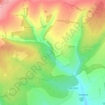
Name: Chalk topographic map, elevation, terrain.
Average elevation: 163 m
Minimum elevation: 92 m
Maximum elevation: 235 m
Make a donation
Other topographic maps
Click on a map to view its topography, its elevation and its terrain.
Salisbury
United Kingdom > England > Wiltshire
Bishop of Salisbury Hubert Walter was instrumental in the negotiations with Saladin during the Third Crusade, but he spent little time in his diocese prior to his elevation to archbishop of Canterbury. The brothers Herbert and Richard Poore succeeded him and began planning the relocation of the cathedral into…
Average elevation: 72 m
Make a donation
Make a donation
Make a donation
Make a donation
Warminster
United Kingdom > England > Wiltshire
Warminster Town Hall, at the junction of the High Street and Weymouth Street, was designed c. 1837 by Edward Blore at the expense of the 5th Marquess of Bath; the two-storey front elevation is a replica of Longleat, with the addition of a central bellcote, clock and coat of arms. The building was sold by the…
Average elevation: 143 m
Make a donation
Make a donation
Cranborne Chase & West Wiltshire Downs National Landscape
United Kingdom > England > Wiltshire
Average elevation: 101 m
Make a donation
Make a donation
Make a donation
Make a donation
Make a donation
Make a donation
Make a donation
Marlborough
United Kingdom > England > Wiltshire > Marlborough
Marlborough has an oceanic climate somewhat influenced by its inland position and at 407 feet (124 m) elevation is more prone to frost than southern coastal areas. For example, in 1909 the town reported the equal lowest temperature in the UK at a station below 1,600 feet (500 m) for that year, with a…
Average elevation: 163 m
Make a donation
Make a donation
Make a donation
Make a donation
Make a donation
Make a donation
Make a donation
Make a donation
Make a donation
Make a donation
Make a donation
Make a donation