Islay topographic map
Interactive map
Click on the map to display elevation.
About this map
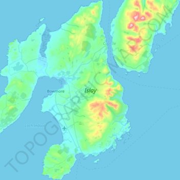
Name: Islay topographic map, elevation, terrain.
Location: Islay, Argyll and Bute, Scotland, United Kingdom (55.57898 -6.52575 55.93823 -6.01906)
Average elevation: 53 m
Minimum elevation: -1 m
Maximum elevation: 766 m
Other topographic maps
Click on a map to view its topography, its elevation and its terrain.
Braemar
United Kingdom > Scotland > Aberdeenshire
Braemar, Aberdeenshire, Scotland, AB35 5YN, United Kingdom
Average elevation: 445 m
Scrabster
United Kingdom > Scotland > Highland
Scrabster, Highland, Scotland, KW14 7UX, United Kingdom
Average elevation: 34 m
Stevenston
United Kingdom > Scotland > North Ayrshire
Stevenston, North Ayrshire, Scotland, KA20 3HE, United Kingdom
Average elevation: 27 m
Galashiels
United Kingdom > Scotland > Scottish Borders
Galashiels, Scottish Borders, Scotland, United Kingdom
Average elevation: 221 m
Scottish Highlands
United Kingdom > Scotland > Highland
Scottish Highlands, Highland, Scotland, United Kingdom
Average elevation: 907 m
Kildonan
United Kingdom > Scotland > Kildonan
Kildonan, Highland, Scotland, KW8 6HY, United Kingdom
Average elevation: 147 m
Scottish Borders
Scottish Borders, Scotland, United Kingdom
Average elevation: 257 m
Harris
Harris, Western Isles, Scotland, United Kingdom
Average elevation: 74 m
Selkirk
United Kingdom > Scotland > Selkirk
Selkirk, Scottish Borders, Scotland, TD7 4BL, United Kingdom
Average elevation: 226 m
Greenbraehead
United Kingdom > Scotland > Greenbraehead
Greenbraehead, Scottish Borders, Scotland, TD9 9SW, United Kingdom
Average elevation: 187 m
Edinburgh
United Kingdom > Scotland > Edinburgh
Edinburgh, City of Edinburgh, Scotland, EH1 1BB, United Kingdom
Average elevation: 105 m
Aberdeen
United Kingdom > Scotland > Aberdeen
Aberdeen, Aberdeen City, Scotland, AB11 5EQ, United Kingdom
Average elevation: 52 m
Stirling
United Kingdom > Scotland > Stirling
Stirling, Scotland, FK8 2DD, United Kingdom
Average elevation: 161 m
Netherley
United Kingdom > Scotland > Netherley
Netherley, Aberdeenshire, Scotland, AB39 3QN, United Kingdom
Average elevation: 152 m
Kirkwall
United Kingdom > Scotland > Kirkwall
Kirkwall, Orkney Islands, Scotland, KW15 1HG, United Kingdom
Average elevation: 27 m
North Connel
United Kingdom > Scotland > Argyll and Bute
North Connel, Argyll and Bute, Scotland, PA37 1PL, United Kingdom
Average elevation: 19 m
Muirhouse/Salvesen
United Kingdom > Scotland > Edinburgh
Muirhouse/Salvesen, Edinburgh, City of Edinburgh, Scotland, United Kingdom
Average elevation: 29 m
Mainland
Mainland, Orkney Islands, Scotland, United Kingdom
Average elevation: 28 m
Spidean Coire nan Clach (Beinn Eighe)
Spidean Coire nan Clach (Beinn Eighe), Highland, Scotland, United Kingdom
Average elevation: 608 m
Ben Nevis
Ben Nevis, Highland, Scotland, United Kingdom
Average elevation: 912 m
Lewis and Harris
Lewis and Harris, Na h-Eileanan Siar, Scotland, United Kingdom
Average elevation: 28 m
Dumfries and Galloway
Dumfries and Galloway, Scotland, United Kingdom
Average elevation: 163 m
Cairngorm Mountains
Cairngorm Mountains, Aberdeenshire, Scotland, United Kingdom
Average elevation: 937 m
Argyll and Bute
Argyll and Bute, Scotland, United Kingdom
Average elevation: 84 m
Kildonan
United Kingdom > Scotland > Kildonan
Kildonan, North Ayrshire, Scotland, KA27 8SD, United Kingdom
Average elevation: 53 m
Glenlivet
United Kingdom > Scotland > Glenlivet
Glenlivet, Moray, Scotland, AB37 9BT, United Kingdom
Average elevation: 280 m
Hecla
Hecla, Na h-Eileanan Siar, Scotland, United Kingdom
Average elevation: 50 m
Waterton
United Kingdom > Scotland > Waterton
Waterton, Aberdeenshire, Scotland, AB41 9QQ, United Kingdom
Average elevation: 32 m
Red Den
Red Den, Angus, Scotland, DD9 6UN, United Kingdom
Average elevation: 56 m
Cairnsmore of Fleet
Cairnsmore of Fleet, Dumfries and Galloway, Scotland, DG8 7BL, United Kingdom
Average elevation: 489 m
Grampian Mountains
Grampian Mountains, Highland, Scotland, United Kingdom
Average elevation: 775 m