
Fenton topographic map
Interactive map
Click on the map to display elevation.
About this map
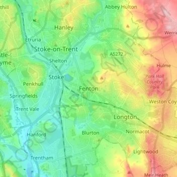
Name: Fenton topographic map, elevation, terrain.
Location: Fenton, Stoke-on-Trent, England, ST4 3JE, United Kingdom (52.95822 -2.19664 53.03822 -2.11664)
Average elevation: 156 m
Minimum elevation: 95 m
Maximum elevation: 275 m
Other topographic maps
Click on a map to view its topography, its elevation and its terrain.
Sandford Hill
United Kingdom > England > Stoke-on-Trent > Longton
Sandford Hill, Longton, Stoke-on-Trent, England, ST3 1AS, United Kingdom
Average elevation: 169 m
Ball Green
United Kingdom > England > Stoke-on-Trent > Norton Green
Ball Green, Norton Green, Stoke-on-Trent, England, ST6 8AW, United Kingdom
Average elevation: 177 m
Eaton Park
United Kingdom > England > Stoke-on-Trent
Eaton Park, Stoke-on-Trent, England, ST2 9ND, United Kingdom
Average elevation: 152 m
Stoke-on-Trent
United Kingdom > England > Stoke-on-Trent
Stoke-on-Trent, West Midlands, England, ST1 4NP, United Kingdom
Average elevation: 160 m