
Mehle topographic map
Interactive map
Click on the map to display elevation.
About this map
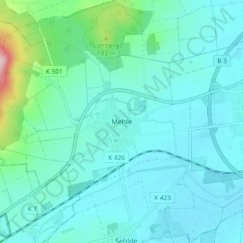
Name: Mehle topographic map, elevation, terrain.
Average elevation: 108 m
Minimum elevation: 75 m
Maximum elevation: 303 m
Other topographic maps
Click on a map to view its topography, its elevation and its terrain.
Esbeck
Deutschland > Niedersachsen > Landkreis Hildesheim > Elze
Esbeck, Elze, Landkreis Hildesheim, Niedersachsen, 31036, Deutschland
Average elevation: 112 m
Wülfingen
Deutschland > Niedersachsen > Landkreis Hildesheim > Elze
Wülfingen, Elze, Landkreis Hildesheim, Niedersachsen, Deutschland
Average elevation: 82 m
Sorsum
Deutschland > Niedersachsen > Landkreis Hildesheim > Elze
Sorsum, Elze, Landkreis Hildesheim, Niedersachsen, 31008, Deutschland
Average elevation: 101 m