
Dadeville topographic map
Interactive map
Click on the map to display elevation.
About this map
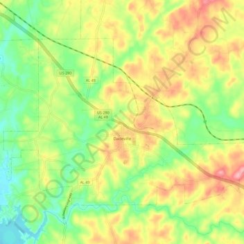
Name: Dadeville topographic map, elevation, terrain.
Location: Dadeville, Tallapoosa County, Alabama, United States (32.80548 -85.81779 32.86960 -85.70654)
Average elevation: 195 m
Minimum elevation: 140 m
Maximum elevation: 260 m
Other topographic maps
Click on a map to view its topography, its elevation and its terrain.
Hawaii Island
United States > Alabama > Tallapoosa County
Hawaii Island, Tallapoosa County, Alabama, United States
Average elevation: 149 m
Lake Martin
United States > Alabama > Tallapoosa County > Alexander City
Lake Martin, Alexander City, Tallapoosa County, Alabama, 36861, United States
Average elevation: 175 m
Camp Hill
United States > Alabama > Tallapoosa County
Camp Hill, Tallapoosa County, Alabama, 36850, United States
Average elevation: 203 m
Carrville
United States > Alabama > Tallapoosa County > Tallassee
Carrville, Tallassee, Tallapoosa County, Alabama, 36078, United States
Average elevation: 112 m
Alexander City
United States > Alabama > Tallapoosa County
Alexander City, Tallapoosa County, Alabama, 35010, United States
Average elevation: 188 m