
Make a donation
Wipperfürth topographic map
Click on the map to display elevation.
Make a donation
About this map
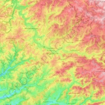
Name: Wipperfürth topographic map, elevation, terrain.
Average elevation: 309 m
Minimum elevation: 173 m
Maximum elevation: 434 m
Make a donation
Other topographic maps
Click on a map to view its topography, its elevation and its terrain.
Blockhaus
Germany > North Rhine-Westphalia > Oberbergischer Kreis > Reichshof > Windfus
Average elevation: 409 m
Hambüchen
Germany > North Rhine-Westphalia > Oberbergischer Kreis > Hückeswagen
Average elevation: 300 m
Remlingrade
Germany > North Rhine-Westphalia > Oberbergischer Kreis > Radevormwald
Average elevation: 306 m
Make a donation
Lützinghausen
Germany > North Rhine-Westphalia > Oberbergischer Kreis > Gummersbach
Average elevation: 310 m
Borner
Germany > North Rhine-Westphalia > Oberbergischer Kreis > Reichshof > Nosbach
Average elevation: 389 m
Make a donation
Kreuzberg
Germany > North Rhine-Westphalia > Oberbergischer Kreis > Wipperfürth
Average elevation: 355 m
Reppinghausen
Germany > North Rhine-Westphalia > Oberbergischer Kreis > Marienheide
Average elevation: 364 m
Niedergaul
Germany > North Rhine-Westphalia > Oberbergischer Kreis > Wipperfürth
Average elevation: 314 m
Make a donation