
Boussekine topographic map
Interactive map
Click on the map to display elevation.
About this map
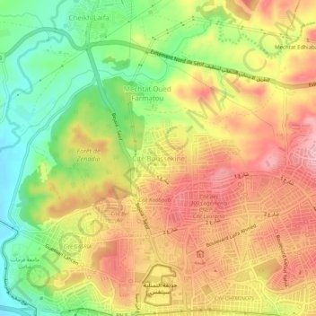
Name: Boussekine topographic map, elevation, terrain.
Location: Boussekine, Sétif, Daïra Sétif, Sétif, 19000, Algérie (36.18907 5.38653 36.22907 5.42653)
Average elevation: 1,075 m
Minimum elevation: 994 m
Maximum elevation: 1,144 m
Other topographic maps
Click on a map to view its topography, its elevation and its terrain.
Sétif
Algérie > Sétif > Daïra Sétif > Sétif
Sétif, Daïra Sétif, Sétif, 19000, Algérie
Average elevation: 1,058 m