
Cherry Log topographic map
Interactive map
Click on the map to display elevation.
About this map
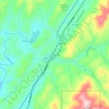
Name: Cherry Log topographic map, elevation, terrain.
Location: Cherry Log, Gilmer County, Georgia, United States (34.76036 -84.41076 34.80036 -84.37076)
Average elevation: 522 m
Minimum elevation: 422 m
Maximum elevation: 728 m
Other topographic maps
Click on a map to view its topography, its elevation and its terrain.
Ellijay
United States > Georgia > Gilmer County
Ellijay, Gilmer County, Georgia, 30540, United States
Average elevation: 424 m
East Ellijay
United States > Georgia > Gilmer County
East Ellijay, Gilmer County, Georgia, United States
Average elevation: 440 m
Chopped Oak
United States > Georgia > Gilmer County
Chopped Oak, Gilmer County, Georgia, United States
Average elevation: 560 m
Diamond
United States > Georgia > Gilmer County
Diamond, Gilmer County, Georgia, United States
Average elevation: 644 m
Carters Lake
United States > Georgia > Gilmer County
Carters Lake, Gilmer County, Georgia, United States
Average elevation: 370 m
Burnett
United States > Georgia > Gilmer County
Burnett, Gilmer County, Georgia, United States
Average elevation: 578 m