
Mountain View Homes topographic map
Interactive map
Click on the map to display elevation.
About this map
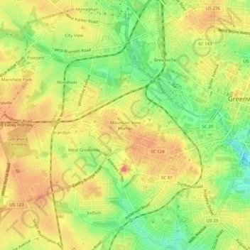
Name: Mountain View Homes topographic map, elevation, terrain.
Average elevation: 299 m
Minimum elevation: 263 m
Maximum elevation: 325 m
Other topographic maps
Click on a map to view its topography, its elevation and its terrain.
Kendall Green
United States > South Carolina > Greenville County > Greenville
Kendall Green, Greenville, Greenville County, South Carolina, 29614, United States
Average elevation: 298 m
Marshall Forest
United States > South Carolina > Greenville County > Greenville
Marshall Forest, Greenville, Greenville County, South Carolina, 29605, United States
Average elevation: 278 m
Alta Vista
United States > South Carolina > Greenville County > Greenville
Alta Vista, Greenville, Greenville County, South Carolina, 29601, United States
Average elevation: 286 m
The Vintage Apartment Homes
United States > South Carolina > Greenville County > Greenville
The Vintage Apartment Homes, Greenville, Greenville County, South Carolina, 29614, United States
Average elevation: 305 m
Boyce Lawn
United States > South Carolina > Greenville County > Greenville
Boyce Lawn, Greenville, Greenville County, South Carolina, 29601, United States
Average elevation: 290 m