
Saint-Loup topographic map
Interactive map
Click on the map to display elevation.
About this map
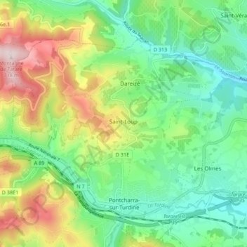
Name: Saint-Loup topographic map, elevation, terrain.
Average elevation: 430 m
Minimum elevation: 283 m
Maximum elevation: 712 m
Other topographic maps
Click on a map to view its topography, its elevation and its terrain.
La Savoie
France > Auvergne-Rhône-Alpes > Rhône > Vindry-sur-Turdine > Pontcharra-sur-Turdine
La Savoie, Pontcharra-sur-Turdine, Vindry-sur-Turdine, Villefranche-sur-Saône, Rhône, Auvergne-Rhône-Alpes, France métropolitaine, 69490, France
Average elevation: 392 m
La Roue
France > Auvergne-Rhône-Alpes > Rhône > Vindry-sur-Turdine > Saint-Loup
La Roue, Saint-Loup, Vindry-sur-Turdine, Villefranche-sur-Saône, Rhône, Auvergne-Rhône-Alpes, France métropolitaine, 69490, France
Average elevation: 461 m
Pontcharra-sur-Turdine
France > Auvergne-Rhône-Alpes > Rhône > Vindry-sur-Turdine
Pontcharra-sur-Turdine, Vindry-sur-Turdine, Villefranche-sur-Saône, Rhône, Auvergne-Rhône-Alpes, France métropolitaine, 69490, France
Average elevation: 412 m