
Oxford topographic map
Interactive map
Click on the map to display elevation.
About this map
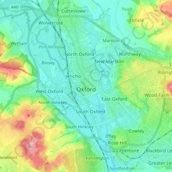
Name: Oxford topographic map, elevation, terrain.
Location: Oxford, Oxfordshire, England, Vereinigtes Königreich (51.71098 -1.30425 51.79627 -1.17581)
Average elevation: 81 m
Minimum elevation: 50 m
Maximum elevation: 170 m
Other topographic maps
Click on a map to view its topography, its elevation and its terrain.
Wittenham Clumps
Vereinigtes Königreich > England > Oxfordshire > South Oxfordshire > Little Wittenham
Wittenham Clumps, Little Wittenham, South Oxfordshire, Oxfordshire, England, OX14 4QZ, Vereinigtes Königreich
Average elevation: 65 m
Banbury
Vereinigtes Königreich > England > Oxfordshire > Cherwell District
Banbury, Cherwell District, Oxfordshire, England, Vereinigtes Königreich
Average elevation: 116 m
Great Coxwell
Vereinigtes Königreich > England > Oxfordshire > Vale of White Horse
Great Coxwell, Vale of White Horse, Oxfordshire, England, Vereinigtes Königreich
Average elevation: 108 m
Faringdon
Vereinigtes Königreich > England > Oxfordshire > Vale of White Horse
Faringdon, Vale of White Horse, Oxfordshire, England, SN7 7HL, Vereinigtes Königreich
Average elevation: 91 m
Thame
Vereinigtes Königreich > England > Oxfordshire > South Oxfordshire
Thame, South Oxfordshire, Oxfordshire, England, Vereinigtes Königreich
Average elevation: 74 m