
Gantillon topographic map
Interactive map
Click on the map to display elevation.
About this map
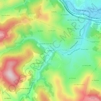
Name: Gantillon topographic map, elevation, terrain.
Average elevation: 512 m
Minimum elevation: 332 m
Maximum elevation: 775 m
Other topographic maps
Click on a map to view its topography, its elevation and its terrain.
Napoly
France > Auvergne-Rhône-Alpes > Rhône > Saint-Forgeux
Napoly, Saint-Forgeux, Villefranche-sur-Saône, Rhône, Auvergne-Rhône-Alpes, France métropolitaine, 69490, France
Average elevation: 643 m
Grand Jean
France > Auvergne-Rhône-Alpes > Rhône > Saint-Forgeux
Grand Jean, Saint-Forgeux, Villefranche-sur-Saône, Rhône, Circonscription départementale du Rhône, Auvergne-Rhône-Alpes, France métropolitaine, 69490, France
Average elevation: 466 m
Fontgarnoud
France > Auvergne-Rhône-Alpes > Rhône > Saint-Forgeux > Fontgarnoud
Fontgarnoud, Saint-Forgeux, Villefranche-sur-Saône, Rhône, Circonscription départementale du Rhône, Auvergne-Rhône-Alpes, France métropolitaine, 69490, France
Average elevation: 441 m