
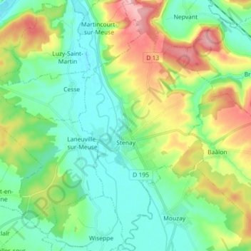
Stenay topographic map
Interactive map
Click on the map to display elevation.
About this map
Name: Stenay topographic map, elevation, terrain.
Average elevation: 204 m
Minimum elevation: 158 m
Maximum elevation: 306 m
Other topographic maps
Click on a map to view its topography, its elevation and its terrain.
Pré d'en Haut
France > Grand Est > Meuse > Récicourt
Pré d'en Haut, Ferme de Verières, Récicourt, Verdun, Meuse, Grand Est, France métropolitaine, 55120, France
Average elevation: 287 m
Les Paroches
Les Paroches, Commercy, Meuse, Grand Est, France métropolitaine, 55300, France
Average elevation: 257 m
Les Monthairons
Les Monthairons, Verdun, Meuse, Grand Est, France métropolitaine, 55320, France
Average elevation: 242 m
La Vallée le Tingre
France > Grand Est > Meuse > Ancerville
La Vallée le Tingre, Ancerville, Bar-le-Duc, Meuse, Grand Est, France métropolitaine, 55170, France
Average elevation: 200 m
Saint-Hypolite
France > Grand Est > Meuse > Rumont > Petit-Rumont
Saint-Hypolite, Petit-Rumont, Rumont, Bar-le-Duc, Meuse, Grand Est, France métropolitaine, 55000, France
Average elevation: 326 m
Revigny-sur-Ornain
Revigny-sur-Ornain, Bar-le-Duc, Meuse, Grand Est, France métropolitaine, 55800, France
Average elevation: 152 m
Saint-Mihiel
Saint-Mihiel, Commercy, Meuse, Grand Est, France métropolitaine, 55300, France
Average elevation: 277 m