
Almaty topographic map
Interactive map
Click on the map to display elevation.
Almaty
Almaty is still the major commercial, financial, and cultural centre of Kazakhstan, as well as its most populous and most cosmopolitan city. The city is located in the mountainous area of southern Kazakhstan near the border with Kyrgyzstan in the foothills of the Trans-Ili Alatau at an elevation of 700–900 m (2,300–3,000 feet), where the Large and Small Almatinka rivers run into the plain. The city, just like Astana and Shymkent, does not belong to any region and is officially a "city of republican significance".
About this map
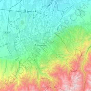
Name: Almaty topographic map, elevation, terrain.
Location: Almaty, Kazakhstan (43.03284 76.73828 43.40377 77.16675)
Average elevation: 1,474 m
Minimum elevation: 631 m
Maximum elevation: 4,386 m
Other topographic maps
Click on a map to view its topography, its elevation and its terrain.