
Stoltenberg topographic map
Interactive map
Click on the map to display elevation.
About this map
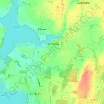
Name: Stoltenberg topographic map, elevation, terrain.
Location: Stoltenberg, Probstei, Plön, Schleswig-Holstein, Deutschland (54.32601 10.31213 54.35408 10.39261)
Average elevation: 31 m
Minimum elevation: 13 m
Maximum elevation: 60 m
Other topographic maps
Click on a map to view its topography, its elevation and its terrain.
Ottenhof
Deutschland > Schleswig-Holstein > Plön > Stoltenberg > Ottenhof
Ottenhof, Stoltenberg, Probstei, Plön, Schleswig-Holstein, 24256, Deutschland
Average elevation: 38 m