
Wallace topographic map
Interactive map
Click on the map to display elevation.
About this map
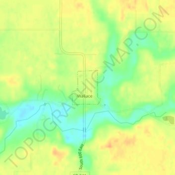
Name: Wallace topographic map, elevation, terrain.
Location: Wallace, Fountain County, Indiana, 47988, United States (39.98508 -87.15095 39.99040 -87.14512)
Average elevation: 215 m
Minimum elevation: 194 m
Maximum elevation: 229 m
Other topographic maps
Click on a map to view its topography, its elevation and its terrain.
Attica
United States > Indiana > Fountain County
Attica, Fountain County, Indiana, United States
Average elevation: 181 m
Kingman
United States > Indiana > Fountain County > Kingman
Kingman, Fountain County, Indiana, United States
Average elevation: 213 m
Stone Bluff
United States > Indiana > Fountain County > Stone Bluff
Stone Bluff, Fountain County, Indiana, 47987, United States
Average elevation: 200 m
Covington
United States > Indiana > Fountain County > Covington
Covington, Fountain County, Indiana, United States
Average elevation: 170 m