
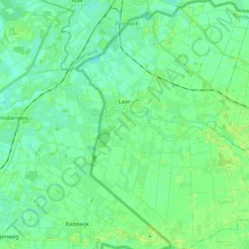
Laar topographic map
Interactive map
Click on the map to display elevation.
About this map
Name: Laar topographic map, elevation, terrain.
Average elevation: 11 m
Minimum elevation: 6 m
Maximum elevation: 17 m
Other topographic maps
Click on a map to view its topography, its elevation and its terrain.
Benthem
Duitsland > Nedersaksen > Landkreis Grafschaft Bentheim
Benthem, Landkreis Grafschaft Bentheim, Nedersaksen, 48455, Duitsland
Average elevation: 38 m
Gölenkamp
Duitsland > Nedersaksen > Landkreis Grafschaft Bentheim
Gölenkamp, Samtgemeinde Uelsen, Landkreis Grafschaft Bentheim, Nedersaksen, Duitsland
Average elevation: 30 m
Nordhorn
Duitsland > Nedersaksen > Landkreis Grafschaft Bentheim
Nordhorn, Landkreis Grafschaft Bentheim, Nedersaksen, Duitsland
Average elevation: 24 m
Zuid-Noordkanaal
Duitsland > Nedersaksen > Landkreis Grafschaft Bentheim
Zuid-Noordkanaal, Landkreis Grafschaft Bentheim, Nedersaksen, 49767, Duitsland
Average elevation: 20 m
Schüttorf
Duitsland > Nedersaksen > Landkreis Grafschaft Bentheim
Schüttorf, Samtgemeinde Schüttorf, Landkreis Grafschaft Bentheim, Nedersaksen, 48465, Duitsland
Average elevation: 39 m