
Tarente topographic map
Interactive map
Click on the map to display elevation.
About this map
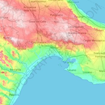
Name: Tarente topographic map, elevation, terrain.
Location: Tarente, Apulië, Italië (40.29447 16.69731 40.80325 17.80042)
Average elevation: 153 m
Minimum elevation: -2 m
Maximum elevation: 522 m
Other topographic maps
Click on a map to view its topography, its elevation and its terrain.
Ceglie Messapica
Ceglie Messapica, Brindisi, Apulië, 72013, Italië
Average elevation: 244 m
San Giovanni Rotondo
Italië > Apulië > Foggia > San Giovanni Rotondo
San Giovanni Rotondo, Foggia, Apulië, 71013, Italië
Average elevation: 295 m