
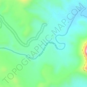
San Rafel Swell overlook topographic map
Interactive map
Click on the map to display elevation.
About this map
Name: San Rafel Swell overlook topographic map, elevation, terrain.
Average elevation: 1,491 m
Minimum elevation: 1,370 m
Maximum elevation: 1,885 m
Other topographic maps
Click on a map to view its topography, its elevation and its terrain.
Orangeville
United States > Utah > Emery County
Orangeville, Emery County, Utah, 84537, United States
Average elevation: 1,776 m
Castle Dale
United States > Utah > Emery County
Castle Dale, Emery County, Utah, 84513, United States
Average elevation: 1,758 m
Huntington
United States > Utah > Emery County > Huntington
Huntington, Emery County, Utah, 84528, United States
Average elevation: 1,767 m
Castle Dale
United States > Utah > Emery County > Castle Dale > Castle Dale
Castle Dale, Emery County, Utah, 84513, United States
Average elevation: 1,745 m
The Wickiup
United States > Utah > Emery County
The Wickiup, Emery County, Utah, United States
Average elevation: 1,979 m
Joes Valley Reservoir
United States > Utah > Emery County
Joes Valley Reservoir, Emery County, Utah, United States
Average elevation: 2,282 m
Green River
United States > Utah > Emery County
Green River, Emery County, Utah, 84525, United States
Average elevation: 1,349 m