
Thank you for supporting this site ❤️
Make a donation
Make a donation
Springe topographic map
Click on the map to display elevation.
Thank you for supporting this site ❤️
Make a donation
Make a donation
About this map
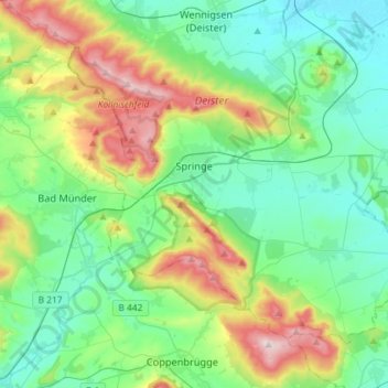
Name: Springe topographic map, elevation, terrain.
Location: Springe, Region Hannover, Lower Saxony, 31832, Germany (52.12836 9.46406 52.26541 9.75358)
Average elevation: 160 m
Minimum elevation: 65 m
Maximum elevation: 416 m
Thank you for supporting this site ❤️
Make a donation
Make a donation
Other topographic maps
Click on a map to view its topography, its elevation and its terrain.
Thank you for supporting this site ❤️
Make a donation
Make a donation
Thank you for supporting this site ❤️
Make a donation
Make a donation
Hanover
Germany > Lower Saxony > Region Hannover > Hanover
In 1636 George, Duke of Brunswick-Lüneburg, ruler of the Brunswick-Lüneburg principality of Calenberg, moved his residence to Hanover. The Dukes of Brunswick-Lüneburg were elevated by the Holy Roman Emperor to the rank of Prince-Elector in 1692 and this elevation was confirmed by the Imperial Diet in 1708.…
Average elevation: 70 m