
Blue Nile topographic map
Interactive map
Click on the map to display elevation.
About this map
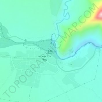
Name: Blue Nile topographic map, elevation, terrain.
Location: Blue Nile, South Gonder, Amhara, Ethiopia (11.48769 37.58613 11.48813 37.58899)
Average elevation: 1,648 m
Minimum elevation: 1,590 m
Maximum elevation: 1,870 m
Other topographic maps
Click on a map to view its topography, its elevation and its terrain.
Ethiopian Highlands
Ethiopian Highlands, North Gondar, Amhara Region, Ethiopia
Average elevation: 4,164 m
May Ch'iwara
Ethiopia > Tigray Region > May Ch'iwara
May Ch'iwara, Central Tigray, Tigray Region, Ethiopia
Average elevation: 2,599 m
Simien Mountains National Park
Simien Mountains National Park, Gich, North Gonder, Amhara, Ethiopia
Average elevation: 2,337 m