
Marne topographic map
Interactive map
Click on the map to display elevation.
About this map
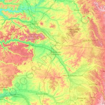
Name: Marne topographic map, elevation, terrain.
Location: Marne, Grand Est, Metropolitan France, France (48.51527 3.39589 49.40742 5.04010)
Average elevation: 148 m
Minimum elevation: 43 m
Maximum elevation: 341 m
Other topographic maps
Click on a map to view its topography, its elevation and its terrain.
Haut Mittlach
France > Grand Est > Mittlach > Haut Mittlach
Haut Mittlach, Mittlach, Colmar-Ribeauvillé, Haut-Rhin, Grand Est, Metropolitan France, 68380, France
Average elevation: 857 m
Roc la Tour
France > Grand Est > Ardennes > Naux
Roc la Tour, Route Forestière des Éteignères, Naux, Thilay, Charleville-Mézières, Ardennes, Grand Est, Metropolitan France, 08800, France
Average elevation: 313 m
Saint-Privat-la-Montagne
France > Grand Est > Saint-Privat-la-Montagne
Saint-Privat-la-Montagne, Metz, Moselle, Grand Est, Metropolitan France, 57855, France
Average elevation: 313 m
Saint-Martin
France > Grand Est > Saint-Martin
Saint-Martin, Lunéville, Meurthe-et-Moselle, Grand Est, Metropolitan France, 54450, France
Average elevation: 262 m
Nouzonville
France > Grand Est > Nouzonville
Nouzonville, Charleville-Mézières, Ardennes, Grand Est, Metropolitan France, 08700, France
Average elevation: 244 m
Vitry-le-François
France > Grand Est > Vitry-le-François
Vitry-le-François, Marne, Grand Est, Metropolitan France, 51300, France
Average elevation: 101 m
Remiremont
France > Grand Est > Remiremont
Remiremont, Épinal, Vosges, Grand Est, Metropolitan France, 88200, France
Average elevation: 515 m
Brunstatt-Didenheim
France > Grand Est > Brunstatt-Didenheim
Brunstatt-Didenheim, Mulhouse, Haut-Rhin, Grand Est, Metropolitan France, France
Average elevation: 285 m
Noviant-aux-Prés
France > Grand Est > Noviant-aux-Prés
Noviant-aux-Prés, Toul, Meurthe-et-Moselle, Grand Est, Metropolitan France, 54385, France
Average elevation: 266 m
Saint-Ciergues
France > Grand Est > Saint-Ciergues
Saint-Ciergues, Langres, Haute-Marne, Grand Est, Metropolitan France, 52200, France
Average elevation: 406 m
Moyeuvre-Grande
France > Grand Est > Moyeuvre-Grande
Moyeuvre-Grande, Thionville, Moselle, Grand Est, Metropolitan France, 57250, France
Average elevation: 263 m
Thionville
France > Grand Est > Thionville
Thionville, Moselle, Grand Est, Metropolitan France, 57100, France
Average elevation: 190 m
Les Granges
France > Grand Est > Les Granges
Les Granges, Troyes, Aube, Grand Est, Metropolitan France, 10210, France
Average elevation: 144 m
Les Nolles
Les Nolles, Corcieux, Saint-Dié-des-Vosges, Vosges, Grand Est, Metropolitan France, 88430, France
Average elevation: 527 m
Haussonville
France > Grand Est > Haussonville
Haussonville, Lunéville, Meurthe-et-Moselle, Grand Est, Metropolitan France, 54290, France
Average elevation: 298 m
Sondernach
France > Grand Est > Sondernach
Sondernach, Colmar-Ribeauvillé, Haut-Rhin, Grand Est, Metropolitan France, 68380, France
Average elevation: 931 m
Place du Marché
France > Grand Est > Drulingen
Place du Marché, Drulingen, Saverne, Bas-Rhin, Grand Est, Metropolitan France, 67320, France
Average elevation: 297 m
Stutzheim-Offenheim
France > Grand Est > Stutzheim-Offenheim
Stutzheim-Offenheim, Saverne, Bas-Rhin, Grand Est, Metropolitan France, 67370, France
Average elevation: 170 m
Champ Moreau
France > Grand Est > Coulommes-et-Marqueny
Champ Moreau, Coulommes-et-Marqueny, Vouziers, Ardennes, Grand Est, Metropolitan France, 08130, France
Average elevation: 135 m
Brabant
France > Grand Est > Velotte-et-Tatignécourt
Brabant, Velotte-et-Tatignécourt, Épinal, Vosges, Grand Est, Metropolitan France, 88270, France
Average elevation: 313 m
Vosges
France > Grand Est > Goldbach-Altenbach
Vosges, Goldbach-Altenbach, Thann-Guebwiller, Haut-Rhin, Grand Est, Metropolitan France, 68760, France
Average elevation: 864 m
Gros Ventre
France > Grand Est > Montépreux
Gros Ventre, Montépreux, Châlons-en-Champagne, Marne, Grand Est, Metropolitan France, 51320, France
Average elevation: 166 m