
Svendborg Municipality topographic map
Interactive map
Click on the map to display elevation.
About this map
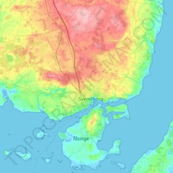
Name: Svendborg Municipality topographic map, elevation, terrain.
Location: Svendborg Municipality, Region of Southern Denmark, Denmark (54.94293 10.36063 55.22160 10.81256)
Average elevation: 31 m
Minimum elevation: -4 m
Maximum elevation: 119 m
Other topographic maps
Click on a map to view its topography, its elevation and its terrain.
Als
Denmark > Region of Southern Denmark
Als, Sønderborg Municipality, Region of Southern Denmark, Denmark
Average elevation: 8 m
Fyn
Denmark > Region of Southern Denmark > Odense
Fyn, Odense, Odense Kommune, Region of Southern Denmark, Denmark
Average elevation: 19 m
Svendborg
Denmark > Region of Southern Denmark > Svendborg
Svendborg, Svendborg Municipality, Region of Southern Denmark, Denmark
Average elevation: 26 m
Region of Southern Denmark
Denmark > Region of Southern Denmark
Region of Southern Denmark, Denmark
Average elevation: 20 m