
Newton topographic map
Interactive map
Click on the map to display elevation.
About this map
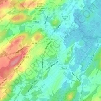
Name: Newton topographic map, elevation, terrain.
Location: Newton, Sussex County, New Jersey, United States (41.03801 -74.77583 41.07095 -74.72999)
Average elevation: 202 m
Minimum elevation: 168 m
Maximum elevation: 274 m
Because of its location in the higher elevations of northwestern New Jersey's Appalachian mountains, Newton, as well as the rest of Sussex County, has a cooler humid continental climate or microthermal climate (Köppen climate classification Dfb) which indicates patterns of significant precipitation in all seasons and at least four months where the average temperature rises above 10 °C (50 °F) This differs from the rest of the state which is generally a humid mesothermal climate, in which temperatures range between −3 °C (27 °F) and 18 °C (64 °F) during the year's coldest month. Sussex County is part of USDA Plant Hardiness Zone 6.