
Okanogan County topographic map
Interactive map
Click on the map to display elevation.
About this map
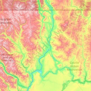
Name: Okanogan County topographic map, elevation, terrain.
Location: Okanogan County, Washington, United States of America (47.94081 -120.88572 49.00057 -118.83520)
Average elevation: 1,076 m
Minimum elevation: 217 m
Maximum elevation: 2,704 m
Other topographic maps
Click on a map to view its topography, its elevation and its terrain.
Whatcom County
United States of America > Washington
Whatcom County, Washington, United States of America
Average elevation: 753 m