
Attica topographic map
Interactive map
Click on the map to display elevation.
About this map
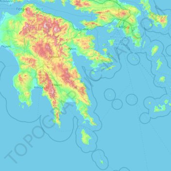
Name: Attica topographic map, elevation, terrain.
Location: Attica, Greece (35.72143 22.76581 38.37816 24.14635)
Average elevation: 155 m
Minimum elevation: -5 m
Maximum elevation: 2,327 m
Other topographic maps
Click on a map to view its topography, its elevation and its terrain.
Athens
Greece > Attica > Regional Unit of Central Athens
Athens, Municipality of Athens, Regional Unit of Central Athens, Attica, 105 57, Greece
Average elevation: 168 m
Συνοικία Κολωνακίου
Συνοικία Κολωνακίου, Athens, Municipality of Athens, Regional Unit of Central Athens, Region of Attica, Attica, Greece
Average elevation: 123 m