
Chitora topographic map
Interactive map
Click on the map to display elevation.
About this map
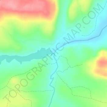
Name: Chitora topographic map, elevation, terrain.
Location: Chitora, Mutoko, Mashonaland East, Zimbabwe (-17.53281 31.94606 -17.53266 31.94663)
Average elevation: 1,113 m
Minimum elevation: 1,068 m
Maximum elevation: 1,180 m
Other topographic maps
Click on a map to view its topography, its elevation and its terrain.
Melfort
Zimbabwe > Mashonaland East > Goromonzi > Melfort
Melfort, Goromonzi, Mashonaland East, Zimbabwe
Average elevation: 1,517 m
Mudzimu Noiringe
Mudzimu Noiringe, Goromonzi, Mashonaland East, Zimbabwe
Average elevation: 1,257 m
Sebakwe River
Sebakwe River, Chikomba, Mashonaland East, Zimbabwe
Average elevation: 1,456 m