
Madhya Pradesh topographic map
Interactive map
Click on the map to display elevation.
About this map
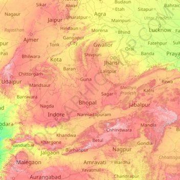
Name: Madhya Pradesh topographic map, elevation, terrain.
Location: Madhya Pradesh, India (21.07517 74.03480 26.86914 82.80784)
Average elevation: 347 m
Minimum elevation: 15 m
Maximum elevation: 1,310 m
Other topographic maps
Click on a map to view its topography, its elevation and its terrain.
Kolapur
India > Madhya Pradesh > Lateri Tahsil
Kolapur, Lateri Tahsil, Vidisha District, Madhya Pradesh, India
Average elevation: 520 m
Sagar
India > Madhya Pradesh > Sagar
Sagar, Sagar Tahsil, Sagar, Madhya Pradesh, 470001, India
Average elevation: 515 m
Narmada
Narmada, Hoshangābād, Hoshangabad, Madhya Pradesh, 481880, India
Average elevation: 380 m
Hoshangābād
Hoshangābād, Hoshangabad, Madhya Pradesh, 461111, India
Average elevation: 427 m