Provincia de El Loa topographic map
Interactive map
Click on the map to display elevation.
About this map
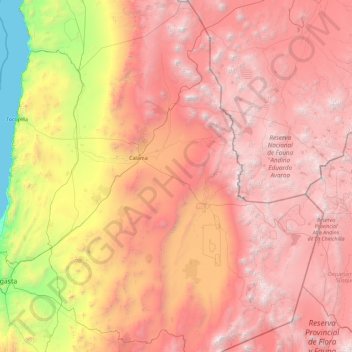
Name: Provincia de El Loa topographic map, elevation, terrain.
Location: Provincia de El Loa, Antofagasta Region, Chile (-24.32816 -69.19413 -20.93439 -66.99052)
Average elevation: 2,937 m
Minimum elevation: 0 m
Maximum elevation: 6,128 m
Other topographic maps
Click on a map to view its topography, its elevation and its terrain.
Tocopilla
Chile > Antofagasta Region > Tocopilla
Tocopilla, Provincia de Tocopilla, Antofagasta Region, Chile
Average elevation: 649 m
Sierra Gorda
Chile > Antofagasta Region > Sierra Gorda
Sierra Gorda, Provincia de Antofagasta, Antofagasta Region, Chile
Average elevation: 1,988 m