
Make a donation
Doha topographic map
Click on the map to display elevation.
Make a donation
Doha
Doha is located on the central-east portion of Qatar, bordered by the Persian Gulf on its coast. Its elevation is 10 m (33 ft). Doha is highly urbanized. Land reclamation off the coast has added 400 hectares of land and 30 km of coastline. Half of the 22 km² of surface area which Hamad International Airport was constructed on was reclaimed land. The geology of Doha is primarily composed of weathered unconformity on the top of the Eocene period Dammam Formation, forming dolomitic limestone.
Make a donation
About this map
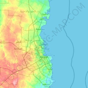
Name: Doha topographic map, elevation, terrain.
Location: Doha, Qatar (25.15054 51.39577 25.68320 52.41712)
Average elevation: 16 m
Minimum elevation: -2 m
Maximum elevation: 79 m
Make a donation
Other topographic maps
Click on a map to view its topography, its elevation and its terrain.
Doha
Doha is located on the central-east portion of Qatar, bordered by the Persian Gulf on its coast. Its elevation is 10 m (33 ft). Doha is highly urbanized. Land reclamation off the coast has added 400 hectares of land and 30 km (19 mi) of coastline. Half of the 22 km2 (8.5 sq mi) of surface area which Hamad…
Average elevation: 12 m
Al Rayyan
The city's name derives from the Arabic word ray, which translates to "irrigation". It was given this name due to its low elevation, allowing it to act as a flood plain during the rainy season and provide a prolonged supply of water to the numerous wild plants and crops that grew in the area.
Average elevation: 21 m
Make a donation
قرين أبو البول
Qurain Abu al-Bawl (also Gurain al Balbul, Gurain al Bâlbûl, Qurain Abul Bul, Qurayn Aba al Bawl, Qurayn Abā al Bawl, Tuwayyir al Hamir) is the highest point of Qatar, with an altitude of 103 metres (338 ft). It is located south of the peninsula near the border to Saudi Arabia.
Average elevation: 65 m
Al Ruwais
The area around Al Ruwais is generally characterized by a flat surface, lacking significant topographical complexities. This resembles much of the northern side of Qatar's coastal plain region, of which Al Ruwais is the northernmost extension. Between Al Jumail and Al Ruwais, the coastline features several…
Average elevation: 5 m
Lusail
Groundwater quality in the area is poor. On the city's border with the Persian Gulf, the groundwater elevation is 1 meter above sea level and flows east-to-west. Salinity levels are highest on the eastern side, at 40 ppt, compared to a low of 18 ppt in the western section; these levels are too high for…
Average elevation: 9 m
Make a donation
Lusail
Groundwater quality in the area is poor. On the city's border with the Persian Gulf, the groundwater elevation is 1 meter above sea level and flows east-to-west. Salinity levels are highest on the eastern side, at 40 ppt, compared to a low of 18 ppt in the western section; these levels are too high for…
Average elevation: 9 m
Al Rayyan
The city's name derives from the Arabic word "ray", which translates to "irrigation". It was given this name due to its low elevation, allowing it to act as a flood plain during the rainy season and provide a prolonged supply of water to the numerous wild plants and crops that grew in the area.
Average elevation: 21 m
Lusail
Groundwater quality in the area is poor. On the city's border with the Persian Gulf, the groundwater elevation is 1 meter above sea level and flows east-to-west. Salinity levels are highest on the eastern side, at 40 ppt, compared to a low of 18 ppt in the western section; these levels are too high for…
Average elevation: 9 m
Make a donation
Make a donation