
Courchevel topographic map
Interactive map
Click on the map to display elevation.
About this map
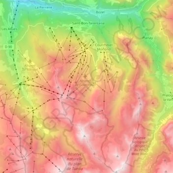
Name: Courchevel topographic map, elevation, terrain.
Average elevation: 1,880 m
Minimum elevation: 603 m
Maximum elevation: 2,994 m
Other topographic maps
Click on a map to view its topography, its elevation and its terrain.
Le Chapet
France > Auvergne-Rhône-Alpes > Savoy > La Giettaz > La Giettaz-en-Aravis
Average elevation: 1,397 m
Glacier de la Grande Casse
France > Auvergne-Rhône-Alpes > Savoy > Pralognan-la-Vanoise
Average elevation: 2,896 m
Villard-Bernon
France > Auvergne-Rhône-Alpes > Savoy > Saint-Michel-de-Maurienne
Average elevation: 1,155 m
Villarabout
France > Auvergne-Rhône-Alpes > Savoy > Saint-Martin-de-Belleville
Average elevation: 1,600 m
Val Thorens
France > Auvergne-Rhône-Alpes > Savoy
Val Thorens ([val tɔʁɑ̃]) is a ski town in the Tarentaise Valley in the French Alps at an altitude of 2,300 m (7,500 ft). It is located in the commune of Saint-Martin-de-Belleville in the Savoie department. The resort forms part of the Les Trois Vallées ski area which, with over 600 km of slopes, is one…
Average elevation: 2,516 m
Praranger
France > Auvergne-Rhône-Alpes > Savoy > Saint-Martin-de-Belleville
Average elevation: 1,867 m
Plagne Villages
France > Auvergne-Rhône-Alpes > Savoy > La Plagne-Tarentaise
Average elevation: 2,104 m
Les Ménuires
France > Auvergne-Rhône-Alpes > Savoy
The resort was founded in 1964 and has an altitude range of 1,850 m (6,070 ft).
Average elevation: 2,063 m
Le Chantel
France > Auvergne-Rhône-Alpes > Savoy > Bourg-Saint-Maurice > Arc 1800
Average elevation: 1,770 m
Val Thorens
France > Auvergne-Rhône-Alpes > Savoy
Val Thorens ([val tɔʁɑ̃]) is a ski town in the Tarentaise Valley in the French Alps at an altitude of 2,300 m (7,500 ft). It is located in the commune of Saint-Martin-de-Belleville in the Savoie department. The resort forms part of the Les Trois Vallées ski area which, with over 600 km of slopes, is one…
Average elevation: 2,516 m
Les Fontanettes
France > Auvergne-Rhône-Alpes > Savoy > Saint-Martin-de-Belleville
Average elevation: 2,085 m
Col de l'Iseran
France > Auvergne-Rhône-Alpes > Savoy > Bonneval-sur-Arc
On both sides of the Col de l'Iseran, mountain pass cycling milestones mark the distance to the summit, the current altitude, and the average slope in the following kilometre.
Average elevation: 2,779 m
Puy Gris
France > Auvergne-Rhône-Alpes > Savoy > Saint-Colomban-des-Villards
Average elevation: 2,469 m
Le Grand Morétan
France > Auvergne-Rhône-Alpes > Savoy > Saint-Colomban-des-Villards
Average elevation: 2,307 m
Saint-Jean-de-Maurienne
France > Auvergne-Rhône-Alpes > Savoy > Saint-Jean-de-Maurienne > Saint-Jean-de-Maurienne
Average elevation: 1,089 m
Plagne Centre
France > Auvergne-Rhône-Alpes > Savoy > La Plagne-Tarentaise > Plagne Centre
Average elevation: 2,078 m
La Toussuire
France > Auvergne-Rhône-Alpes > Savoy > Fontcouverte-la-Toussuire
Average elevation: 1,710 m
Lac supérieur de Rhêmes-Golette
France > Auvergne-Rhône-Alpes > Savoy > Tignes
Average elevation: 3,047 m
Val Thorens
France > Auvergne-Rhône-Alpes > Savoy
Val Thorens ([val tɔʁɑ̃]) is a ski town in the Tarentaise Valley in the French Alps at an altitude of 2,300 m (7,500 ft). It is located in the commune of Saint-Martin-de-Belleville in the Savoie department. The resort forms part of the Les Trois Vallées ski area which, with over 600 km of slopes, is one…
Average elevation: 2,516 m
Le Grand Couloir
France > Auvergne-Rhône-Alpes > Savoy > Pralognan-la-Vanoise > Le Grand Couloir
Average elevation: 1,876 m
Plagne Montalbert
France > Auvergne-Rhône-Alpes > Savoy > Aime-la-Plagne > Plagne Montalbert
Average elevation: 1,188 m