
Al Hoceima Province topographic map
Interactive map
Click on the map to display elevation.
About this map
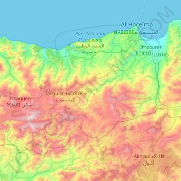
Name: Al Hoceima Province topographic map, elevation, terrain.
Location: Al Hoceima Province, Tangier-Tetouan-Al Hoceima, Morocco (34.66802 -4.79365 35.26197 -3.80269)
Average elevation: 719 m
Minimum elevation: 0 m
Maximum elevation: 2,433 m
Other topographic maps
Click on a map to view its topography, its elevation and its terrain.