
Vorarlberg topographic map
Interactive map
Click on the map to display elevation.
About this map
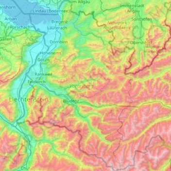
Name: Vorarlberg topographic map, elevation, terrain.
Location: Vorarlberg, Austria (46.84086 9.53075 47.59610 10.23716)
Average elevation: 1,382 m
Minimum elevation: 392 m
Maximum elevation: 3,386 m
Other topographic maps
Click on a map to view its topography, its elevation and its terrain.
Marktgemeinde Schruns
Austria > Vorarlberg > Marktgemeinde Schruns
Marktgemeinde Schruns, Bezirk Bludenz, Vorarlberg, 6780, Austria
Average elevation: 1,375 m
Schwarzenberg
Austria > Vorarlberg > Schwarzenberg
Schwarzenberg, Bregenz, Vorarlberg, Austria
Average elevation: 868 m
Schlins
Austria > Vorarlberg > Schlins
Schlins, Feldkirch, Vorarlberg, 6824, Austria
Average elevation: 558 m
Verwall Alps
Austria > Vorarlberg > Silbertal
Verwall Alps, Silbertal, Bludenz, Vorarlberg, Austria
Average elevation: 1,957 m