
Yucatán topographic map
Interactive map
Click on the map to display elevation.
About this map
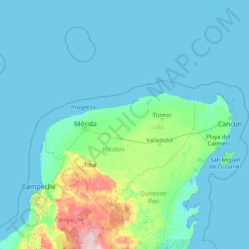
Name: Yucatán topographic map, elevation, terrain.
Location: Yucatán, Mexico (19.55117 -90.40702 21.62509 -87.53315)
Average elevation: 28 m
Minimum elevation: -4 m
Maximum elevation: 239 m
The State of Yucatán is located on the Yucatán Peninsula. It borders the states of Campeche to the southwest, Quintana Roo to the east and southeast, and the Gulf of Mexico to the north and west. As a whole, the state is extremely flat with little or no topographic variation, with the exception of the Puuc hills, located in the southern portion of the state.
Other topographic maps
Click on a map to view its topography, its elevation and its terrain.
San Felipe Nuevo
Mexico > Yucatán > Tinum > San Felipe Nuevo
San Felipe Nuevo, Tinum, Yucatán, 97751, Mexico
Average elevation: 27 m