
West Flanders topographic map
Interactive map
Click on the map to display elevation.
About this map
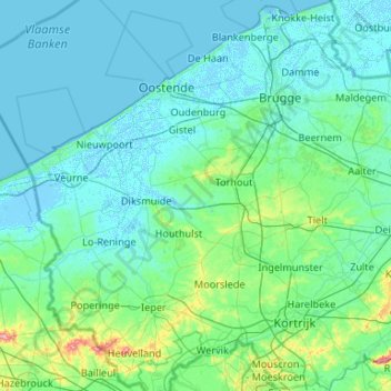
Name: West Flanders topographic map, elevation, terrain.
Location: West Flanders, Flanders, Belgium (50.70826 2.54165 51.37228 3.52345)
Average elevation: 14 m
Minimum elevation: -4 m
Maximum elevation: 162 m
Other topographic maps
Click on a map to view its topography, its elevation and its terrain.
Oostduinkerke
Belgium > Flanders > Groenendijk
Oostduinkerke, Groenendijk, Veurne, West Flanders, Flanders, 8620, Belgium
Average elevation: 3 m
Maasmechelen
Belgium > Flanders > Maasmechelen
Maasmechelen, Tongeren, Limburg, Flanders, Belgium
Average elevation: 57 m