
Kinki Region topographic map
Interactive map
Click on the map to display elevation.
About this map
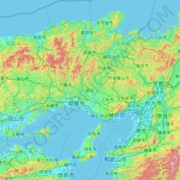
Name: Kinki Region topographic map, elevation, terrain.
Location: Hyogo Prefecture, Kinki Region, Japan (34.01222 134.25274 35.87451 135.46859)
Average elevation: 198 m
Minimum elevation: -4 m
Maximum elevation: 1,850 m
Other topographic maps
Click on a map to view its topography, its elevation and its terrain.
Osaka
Japan > Kinki Region > Osaka
Kita, Osaka, Osaka Prefecture, Kinki Region, Japan
Average elevation: 10 m